Field work reports
Status report 2023
Between 21-24 th of August 2023 the reconaissance survey for the project have been completed from the r/v OCEANIa in Isfjorden area. We have checked seven locations, in the outer and inner Isfjorden, collecting photos of the coast (driftwood) and manually collecting macroplastic on the 100 m long units of the shore.
The localities visited:
| place | latitude | longitude | note | photo |
| Wilkinsbukta | 78°12.319’ N | 13°09.054 E | four plastic transects |  |
| Tryghamna | 78°15.537’ N | 13°46.475 E | three plastic transects |  |
| Randvika | 78°03.692’ N | 13°37.644 E | six plastic transects |  |
| Fredheim | 78°21.315’ N | 16°55.938 E | five plastic transecs |  |
| Bjonapynten | 78°23.115’ N | 16°50.900 E | five plastic transecs |  |
| Tunabreen | 78°25.735’ N | 17o22.498 E | five plastic transecs |  |
| Gipsvika | 78°25.621’ N | 16°35.729 E | eight plastic transecs |  |
Status report 2024
Between 15th and 30th August 2024 four groups were collected data for the project in the field.
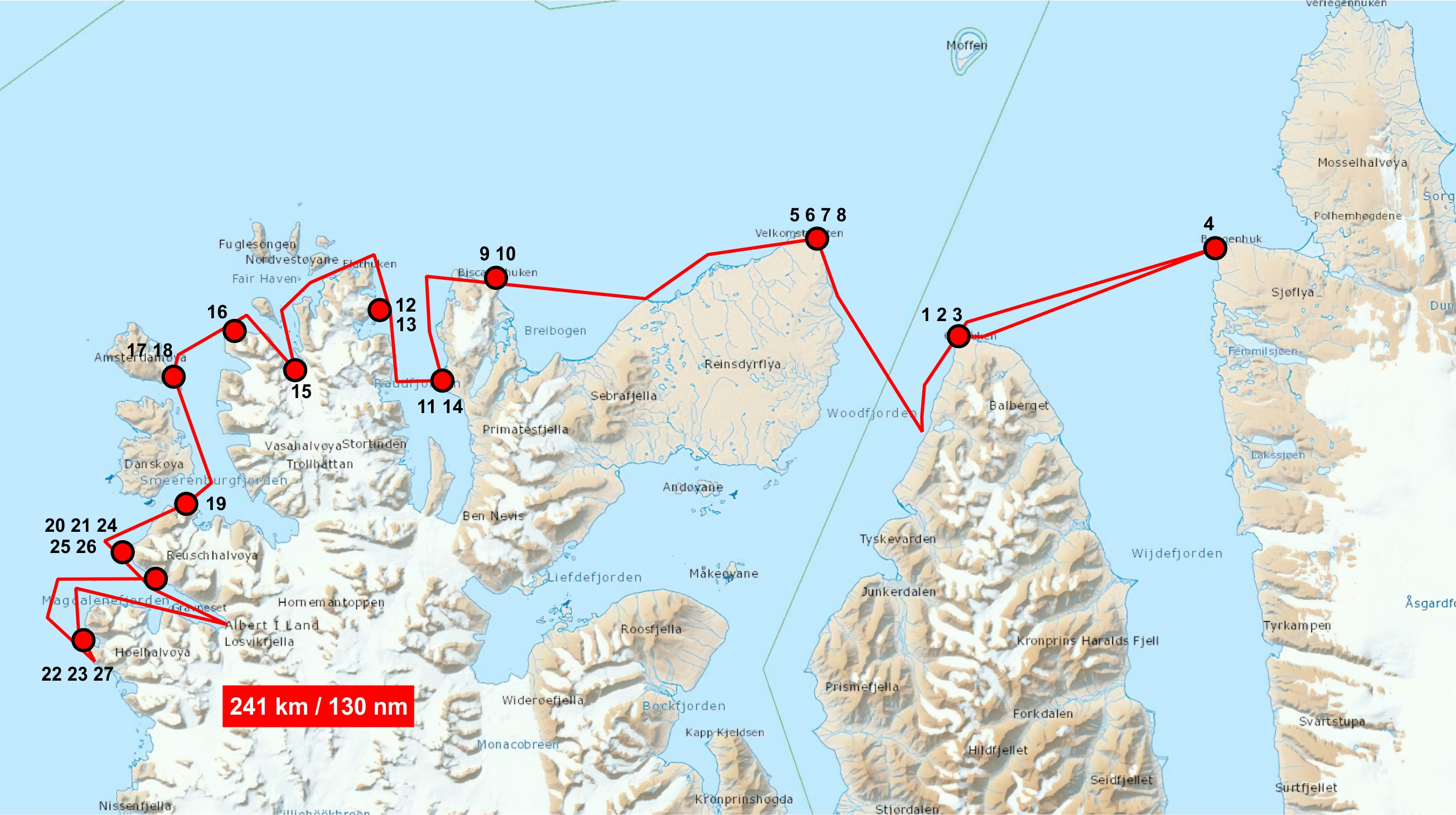
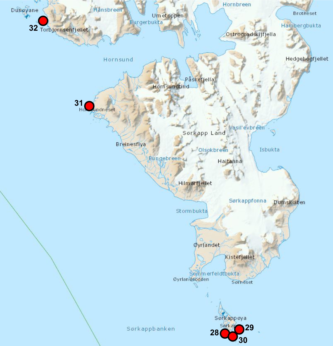
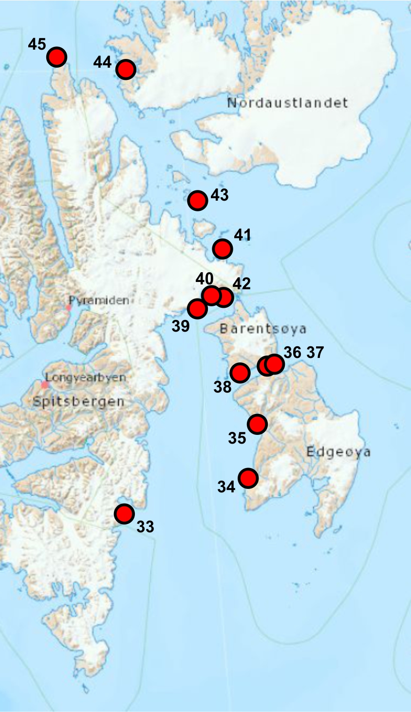
Fig. 1 Sampling stations maps

Sampling stations and route covered by boat team North West Spitsbergen
18-26th August 2024, RIS 12284 |

Sampling stations covered by team
South Spitsbergen 12-17th August 2024 |

Sampling stations covered
by team East Spitsbergen
15-30th August 2024
|

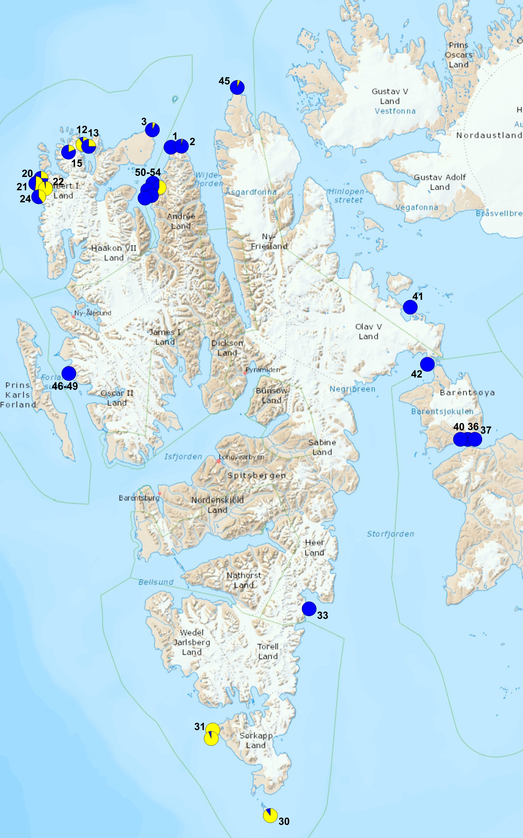
Gammarus species distribution:
blue G.setosus
yellow G. oceanicus
|
Table 1. Data from sampling on NW Spitsbergen coast.
| nr |
place name |
latitude |
longitude |
GPS
nr |
day |
hour |
coast type |
plastic count area |
Mytilus - living |
Fucus |
Littorina |
Gamm.
oceanicus % |
Gamm.
setosus % |
remarks |
photo |
| 1 |
Grahuken hytte |
79.47.274 |
14.27.421 |
55 |
2024.08.18 |
07.03 |
flat, gravel and stones beach with low skjerra |
100m along dift zone |
|
|
|
0 |
100 |
|
 |
| 2 |
Grahuken Tip |
79.48.045 |
14.32.019 |
56 |
2024.08.18 |
10.15 |
flat, gravel and stones beach with low skjerra |
100m along dift zone |
|
x |
|
3 |
97 |
|
 |
| 3 |
Grahuken E |
79.47.833 |
14.32.602 |
57 |
2024.08.18 |
10.37. |
flat, gravel and stones beach with low skjerra |
100m along dift zone |
|
x |
|
|
|
|
 |
| 4 |
Bangehuk |
79.48.455 |
15.37.562 |
59 |
2024.08.18 |
14.23 |
steep stony beach with low skjerra |
100m along dift zone |
|
x |
|
|
|
|
 |
| 5 |
Velkomspynten E |
79.51.549. |
13.51.778 |
60 |
2024.08.19 |
09.26 |
flat, gravel and stones beach with low skjerra |
100m along dift zone |
|
x |
|
7 |
93 |
number of Ascophyllum fronds drifted ashore |
 |
| 6 |
Velkomspynten Tip |
79.51.682 |
13.51.595 |
61 |
2024.08.19 |
10.10 |
flat, gravel and stones beach with low skjerra |
100m along dift zone |
|
x |
|
|
|
|
 |
| 7 |
Velkomspynten W |
79.52.632 |
13.43.855 |
62 |
2024.08.19 |
|
flat, gravel and stones beach with low skjerra |
100m along dift zone |
|
x |
|
|
|
|
 |
| 8 |
Velkomspynten WW |
79.52.343 |
13.41.918 |
63 |
2024.08.19 |
12.37 |
flat, gravel and stones beach with low skjerra |
100m along dift zone |
|
x |
|
|
|
|
 |
| 9 |
Biskayarhuken E |
79.55.006 |
12.22.751 |
64 |
2024.08.20 |
14.20 |
flat, gravel and stones beach with low skjerra |
100m along dift zone |
|
x |
|
|
|
walruses 2 ind. Haul out |
 |
| 10 |
Biskayarhuken
- Lingbukta |
79.50.009 |
12.22.741 |
65 |
2024.08.20 |
14.25 |
flat, gravel and stones beach with low skjerra |
100m along dift zone |
|
x |
|
|
|
Mytilus on fishing box |
 |
| 11 |
Raudfjordhytta |
79.44.581 |
12.12.065 |
66 |
2024.08.20 |
15.41 |
flat, gravel and stones beach with low skjerra |
100m along dift zone |
x |
|
|
|
|
Ivory gull at the hut |
 |
| 12 |
Flathuken |
79.50.463 |
11.47.449 |
67 |
2024.08.21 |
09.55 |
steep stony beach with boulders |
100m along dift zone |
|
x |
x |
91 |
9 |
|
 |
| 13 |
Hundneset |
79.48.321 |
11.50.844 |
69 |
2024.08.21 |
10.25 |
steep stony beach with boulders |
100m along dift zone |
|
x |
x |
25 |
75 |
|
 |
| 14 |
Raudfjord
- Snotinden |
79.45.037 |
11.55.865 |
70 |
2024.08.21 |
12.30 |
sandy beach with boulders |
100m along dift zone |
|
x |
|
|
|
|
 |
| 15 |
Fuglefjorden
skjerra |
79.46.719 |
11.27.458 |
71 |
2024.08.22 |
11.05 |
high skjerra, rocky walls |
100m along dift zone |
|
x |
x |
19 |
81 |
|
 |
| 16 |
Fuglepynten |
79.46.936 |
11.12.874 |
72 |
2024.08.22 |
11.46 |
steep stony beach with boulders |
100m along dift zone |
|
x |
|
|
|
|
 |
| 17 |
Smeerenbukta |
79.44.711 |
10.57.756 |
73 |
2024.08.22 |
12.45 |
sandy beach with boulders |
1 m2 series of photos |
|
|
|
|
|
|
 |
| 18 |
Smeerenburgodden |
79.44.055 |
10.58.893 |
79 |
2024.08.22 |
13.37 |
sandy beach with boulders |
100m along dift zone |
|
|
|
|
|
|
 |
| 19 |
Bjornhamna |
79.38.449 |
10.58.974 |
80 |
2024.08.22 |
14.37 |
steep stony beach |
100m along dift zone |
|
x |
|
|
|
|
 |
| 20 |
Gravnesoden |
79.33.637 |
11.02.065 |
81 |
2024.08.23 |
07.17 |
flat, gravel and stones beach with low skjerra |
100m along dift zone |
|
x |
|
26 |
74 |
|
 |
| 21 |
Alkekongen beach camp |
79.34.311 |
11.03.934 |
82 |
2024.08.23 |
08.25 |
flat, gravel and stones beach with low skjerra |
100m along dift zone |
|
x |
|
52 |
48 |
|
 |
| 22 |
Hamburgbukta S shore |
79.31.575 |
10.41.637 |
83 |
2024.08.24 |
09.18 |
flat, gravel and stones beach with low skjerra |
100m along dift zone |
x |
x |
x |
97 |
3 |
Phoca vitulina 8-11 ind. |
 |
| 23 |
Hamburgbukta N shore |
79.31.895 |
10.43.222 |
85 |
2024.08.24 |
13.18 |
flat, gravel and stones beach with low skjerra |
100m along dift zone |
|
x |
|
|
|
polar bear moving S alongshore |
 |
| 24 |
Magdalenafjorden
- Methenbreen |
79.33.558 |
11.13.195 |
86 |
2024.08.25 |
10.25 |
steep stony beach with boulders |
100m along dift zone |
|
x |
|
40 |
60 |
|
 |
| 25 |
Magdalenafjorden
- Alkebreen |
79.33.875 |
11.09.688 |
87 |
2024.08.25 |
12.23 |
steep stony beach with boulders |
100m along dift zone |
|
x |
|
|
|
peat sample |
 |
| 26 |
Magdalenafjorden
- Gullybukta |
79.33.462 |
79.33.558 |
88 |
2024.08.25 |
16.12 |
sandy beach with boulders |
100m along dift zone |
|
|
|
|
|
walruses 11-12 ind. Haul out |
 |
| 27 |
Hamburgbukta
open sea shore |
79.31.686 |
10.40.173 |
83A |
2024.08.24 |
11.30 |
steep stony beach with boulders, rocky walls |
100m along dift zone |
|
x |
|
|
|
peat sample |
 |
| 46 |
Hornbaeckbukta 1
Kaffioyra |
78.40,869 |
11.49,971 |
|
|
|
|
|
|
|
|
0 |
100 |
|
|
| 47 |
Hornbaeckbukta 2
Kaffioyra |
78.40,869 |
11.49,971 |
|
|
|
|
|
|
|
|
0 |
100 |
|
|
| 48 |
Hornbaeckbukta 3
Kaffioyra |
78.40,869 |
11.49,971 |
|
|
|
|
|
|
|
|
0 |
100 |
|
|
| 49 |
Hornbaeckbukta 4
Kaffioyra |
78.40,869 |
11.49,971 |
|
|
|
|
|
|
|
|
0 |
100 |
|
|
| 50 |
Woodfjorden 2
Oceania |
79.6,522' |
14.03,767' |
|
|
|
|
|
|
|
|
0 |
100 |
|
|
| 51 |
Woodfjorden 6
Oceania |
79.6,522' |
14.03,767' |
|
|
|
|
|
|
|
|
56 |
44 |
|
|
| 52 |
Woodfjorden 7
Oceania |
79.6,522' |
14.03,767' |
|
|
|
|
|
|
|
|
0 |
100 |
|
|
| 53 |
Woodfjorden 9
Oceania |
79.6,522' |
14.03,767' |
|
|
|
|
|
|
|
|
0 |
100 |
|
|
| 54 |
Woodfjorden 11
Oceania |
79.6,522' |
14.03,767' |
|
|
|
|
|
|
|
|
0 |
100 |
|
|
North West Spitsbergen team, operated from yacht r/v OCEANIA and two zodiac boats collected 27 sampling stations (see the map and the table).
Team consisted of: Jan Marcin Węsławski, Lech Kotwicki, Jakub Witek, Marcin Górski and Błażej Kotwicki.
Table 2. Data from sampling on South Spitsbergen coast.
| nr | place name | latitude | longitude | GPS
nr | day | hour | coast type | plastic count area | Mytilus - living | Fucus | Littorina | Gamm.
oceanicus % | Gamm.
setosus % | remarks | photo |
| 28 | Sorkappoya Sorkappvatnet W | 76° 27.995' | 16° 34.241' | | 2024.08.12 | | flat, stony beach | 10 areas 10 x 15 m, four photos each | | x | | | | |  |
| 29 | Sorkappoya Sorkappvatnet E | 76° 28.164' | 16° 35.045' | | 2024.08.12 | | flat, gravel, stony beach with skjerra | 10 areas 10 x 15 m, four photos each 4 | | x | | | | |  |
| 30 | Sorkappoya | 76° 27.866' | 16° 34.613' | | 2024.08.12 | | flat, stony beach | none | | x | | 90 | 10 | |  |
| 31 | Palffyodden | 76° 53.906' | 15° 31.162' | | 2024.08.15 | | skjerra with stony beach | none | | x | | 100 | 0 | |  |
| 32 | Hyttevika | 77° 02.910' | 15° 08.317' | | 2024.08.17 | | flat stony beach with skjerra | none | | x | | 95 | 5 | |  |
South Spitsbergen team operated with the support of yacht Ocean B, and one zodiac team consisted of Ryszard Siwecki, Adam Siwecki and Paweł Paździor.
Table 3. Data from sampling on East Spitsbergen coast.
| nr | place name | latitude | longitude | GPS
nr | day | hour | coast type | plastic count area | Mytilus - living | Fucus | Littorina | Gamm.
oceanicus % | Gamm.
setosus % | remarks | photo |
| 33 | Hambergbukta (Spits. East) | N 77°02’19’’
| E 17°04’38’’ | | 2024.08.20 | | low moraine beach, sand, gravel, stones | 3 (100 x 20m) | | | | | | freshwater outfloiw |  |
| 34 | Russebukta (Edgeøya) | N 77°35’16’’
| E 21°00’05’’ | | 2024.08.21 | | low gravel beach, rocks | 100 x 30m | | x | | 0 | 100 | skjerra |  |
| 35 | Diskobukta (Edgeøya) | N 77°49’24’’
| E 21°21’44’’ | | 2024.08.22 | | low, gravel and stony beach | 2 (100 x 10m) | | | | | | no driftwood |  |
| 36 | Kapp Waldburg (Barentsøya) | N 78°15’31’’ | E 21°56’13’’ | | 2024.08.23 | | low gravel beach | 100 x 10m | | | | | | strong currents |  |
| 37 | Kapp Waldburg (Barentsøya) | N 78°15’44’’ | E 22°03’49’’ | | 2024.08.23 | | narrow, low, initial stony beach | | | | | 0 | 100 | no driftwood, strong currents |  |
| 38 | Sundbukta (Barentsøya) | N 78°13’08’’ | E 20°59’31’’ | | 2024.08.24 | | low, gravel and stony beach | 3 (10 x 100m) | | | | 0 | 100 | |  |
| 39 | Anderssonbukta (Barentsøya) | N 78°18’50’’ | E 20°37’27’’ | | 2024.08.25 | | low, gravel and stony beach | 100 x 5m | | x | | | | narrow driftline |  |
| 40 | Edlundhamna (Spits. East) | N 78°37’17’’ | E 20°00’39’’ | | 2024.08.26 | | low, boulder, sand and stony beach | 100 x 10m | | | | 0 | 100 | |  |
| 41 | Kapp Weyprecht (Spits. East) | N 78°53’39’’ | E 20°53’20’’ | | 2024.08.27 | | low, boulder, sand and stony beach | 100 x 20m | | | | 0 | 100 | |  |
| 42 | Straumslandet (Spits. East) | N 78°41’02’’ | E 21°06’47’’ | | 2024.08.28 | | | | | | | | | long narrow bay, low driftwood | |
| 43 | Von Otterøya (Hinlopen Straits) | N 79°15'04" | E 19°59'42" | | 2024.08.26 | | stony beach | 2 (100 x 20m) | | | | 0 | 100 | |  |
| 44 | Murchisonfjorden (Nordaustlandet) | N 79°55'29" | E 18°10'23" | | 2024.08.27 | | narrow, sand and gravel beach | | | | | | | no driftwood |  |
| 45 | Verlegenhuken (Spits. North) | N 80°02'57" | E 16°11'18" | | 2024.08.28 | | low, sand and gravel beach | 2 (100 x 30m) | | | | 6 | 94 | lots of driftwood |  |
East Spitsbergen team operated with the support of yacht Ocean A, and collection was performed by Maciej Chełchowski between 15-30th August 2024.


