|
 The Island of Sylt is located in the German Bight of the North Sea and encloses the Sylt/Rømø Basin in the North Frisian Wadden Sea, Germany.
The basin is a semi-enclosed lagoon, connected to the North Sea with a channel (the Lister Tief) in the north. The southern boundary of the basin is closed by a dam that connects the island with the main land.
The influence of freshwater in the basin via atmospheric input or fresh water run off is small, being less than one thousandth of the tidal water exchange with the North Sea.
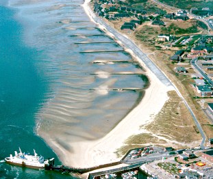
The investigated intertidal flat is situated south of List Harbour and stretches over approx. 500 m in a north south direction. The distance from the low water line to the high water line is 80-100 m.
The flat is protected from the prevailing westerly winds by the island, and from currents by a short dam. However, currents may be quite strong reaching ~1ms-1. Tides are semi-diurnal and the tidal amplitude is ca. 1-2 m. The origin of the sand is mainly eolic.
|

